 |
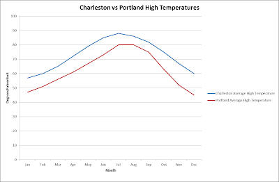
| The difference in location of Charleston and Portland affect their climate |
I
chose to compare Charleston, SC to Portland, OR due the contrast in locations
within the United States. When comparing
the high temperatures, they follow a similar pattern with Portland 8-12 F cooler throughout the year.
The more northern location of Portland explains the difference while the
similar climate pattern is a result of both being in the Northern Hemisphere
and being affected by maritime air masses.
The difference between being located on the coast, Charleston, and 65 miles inland, Portland, is seen when comparing the average low
temperatures. The average low
temperatures in Portland are lower especially in the winter. This means the difference between the high
and low on any given day is much greater in Portland. This is a result of continentality.
 |
The maritime air masses the influence the two cities produce similar weather
patterns. The difference in temperature can be attributed to the more northern
location of Portland.
|
 |
The air cools much more rapidly in Portland at night due to its location inland
from the Pacific ocean.
|
Charleston and Portland receive very similar levels of precipitation but
receive it at different times of the year.
This is a result of the stability of the air masses influencing the
climate of the two cities. In Portland, the
majority of the precipitation is received during the winter months while the
summer months are much drier. This is
because the more unstable Maritime polar air mass is the driver of the winter
weather while the more stable Maritime tropical air mass is the driver in the
summer. In Charleston, the difference in
precipitation is not as drastic as in Portland but there is a significant peak
during the summer. This corresponds to
when the Bermuda High air mass is most unstable.
 |
Sources:


