Predicted Weather Change
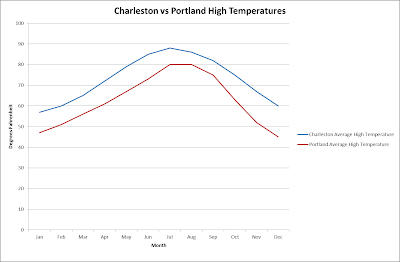
According to the Intergovernmental Panel on Climate Change, Charleston is predicted to experience a 2.5º to 3.0º C increase in surface temperatures. It is also expected that Charleston will see more frequent and intense precipitation than in years past. In general, Charleston’s climate is expected to become warmer and wetter as time passes by. |
| Source: IPPC's Climate Change 2007 |
In addition
to these climate changes, Charleston will see an uptick in extreme
weather. This extreme weather will come
in three forms. The first form is that
not only will there be increases in average temperatures but there will be more
frequent and longer heat spells. In the
case of precipitation as not only will Charleston see more precipitation but
there will be more cases of heavy rain which will cause more flooding. Charleston, if the predictions hold true, can
expect to see a higher frequency in Hurricanes.
Again, the intensity of these storms will coincide with the higher frequency,
in the form of higher wind speeds and storm surges. In addition to these local conditions,
Charleston could be affected by higher sea levels at the global level.
 |
| This could become a common occurrence on the commute home Source:http://www.postandcourier.com/article/20110423/PC1602/304239969 |
Consequences
Environment –
At an environmental level the biggest consequences of climate change is the flooding
of the wetlands of Charleston. Wetlands
are an extremely important part of the ecosystem and provide a large array of
benefits. Wetlands are areas where
groundwater or standing waters create an extremely saturated environment in
which plants suited for wet conditions thrive and a wide variety of wildlife
reside. Swamps, marshes, and bogs are
all considered to be wetlands. The EPA
states that wetlands provide benefits such as a natural fresh water filter,
storing floodwaters, and control erosion.
The loss of these lands means Charleston could become even more
susceptible to floods and the proverbial ecosystem dominos would begin to fall
in the whole area.
 |
| The Wetlands of Charleston, SC Source: science.howstuffworks.com |
Public Health
– The impact of climate change will be felt in the arena of public health. With longer and hotter heat waves, the risk
of heat stroke will increase greatly.
The elderly, young, and poor are especially at risk. There has been a rising increase in heat
stroke related deaths in the south and that will only increase. An increase in flooding will also have a
negative impact on public health. With
an increase in flooding, there will be a corresponding increase in standing
water for periods of time. Standing
water carries dangerous pathogens that can leave people critically ill. Once again the elderly, young, and poor will
be at a higher risk. Finally, as
mentioned before the destructive forces of Hurricanes will always have a
negative impact on the communities public health.
Economics - Two
economic drivers of Charleston will be greatly impacted by the predicted
weather and climate changes that are predicted.
They two economic sectors are tourism and shipping. Charleston has become a tourist destination
as a result of its famous hotels, coastline, and golf courses. If the climate becomes wetter, many of these
outdoor activities that draw people to Charleston will lose their luster. The money will not be brought into the local
economy. If the weather does become more
extreme at a higher rate, shipping companies will have to analyze their risk in
using Charleston port as a major logistical center. Once again this will mean fewer dollars for
the local economy. Another concern for
the shipping industry is the possibility of rising sea levels. This could affect the depth and geography of
the harbor. If there was significant
change, the harbor could become unsuitable for the large container vessels and
all together wipe out the shipping industry.
At the very least, billions of dollars could be needed to deepen the
harbor or fill the new coast line to restore it to its original condition.
 |
Perfect Weather for a Beach Vacation
Source: travelandleisure.com
|
 |
| Charleston Port, will it remain viable? Source: siteselection.com |
Mitigative Measures
Protect and Restore
the Wetlands – While the increase in flooding and higher sea levels attributed
to climate change may destroy existing wetlands no matter what, the destruction
by mankind should be prevented. The city
should adopt a land use ordinance that restricts new development from taking
place in the wetland areas. Policymakers
in Charleston should also look beyond just preserving the wetlands. They should be aiming to restoring previously
filled and developed wetlands.
Thankfully when wetlands are filled and developed over they are not
lost. The EPA has guidelines and best
practices in wetland restoration that the government of Charleston can and
should take advantage of. By putting
these policies into place, Charleston will have a more natural and effective
flood control system and the ecosystem may move to a more natural state
improving the overall environment of the region.
Invest in
Flood Prevention Infrastructure – The current system of levee’s, seawalls,
pumps, and drainage systems should be examined.
Unfortunately, as the world saw in New Orleans during Hurricane Katrina,
these systems are probably insufficient in providing protection from high
category hurricanes. Money should be
secured and projects prioritized to increase the capacity of these
systems. While these systems cannot
completely shield the city from severe weather, they can reduce the risk of a
catastrophic event.


